
One of the underlying philosophies of the social determinants of health is that place matters. The conditions of the neighborhood you grow up in, the air you breathe, and the job opportunities you have can have a profound impact on how long and how well you live, and these things are frequently experienced by communities, not just individuals. Maps can be profound tools for telling stories about public health.
Maps are especially helpful reporting tools. Take this map included in a Pactio story about the increase in heat-related illnesses at public schools in Los Angeles. It led reporter Molly Peterson to ask why some schools had so many more illnesses than others. Her reporting revealed a disturbing trend: It’s not the hottest part of the city where kids are most likely to get sick, but the places with the poorest schools. Maps can help you figure out the questions your reporting needs to answer.
A recent Washington Post investigation examining unsolved murders used side-by-side maps to show how unsolved murders are concentrated in particular cities, and importantly, particular neighborhoods within those cities. But it also made use of photographs that quietly recall the places where horrific, unsolved murders took place, humanizing the numbers. The text details how the stress radiating from communities that don’t trust police or where rampant gang violence makes it dangerous to cooperate with authorities has had a negative impact on the health of residents.
A series of maps produced by The New York Times in 2016 helped illustrate how a state’s political decisions — in this case, whether or not to expand Medicaid under the Affordable Care Act — led to dramatic differences between states over the course of four years.
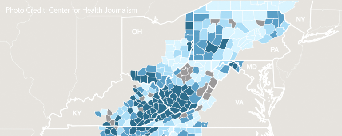
And while not a work of journalism, NORC, a research institution at the University of Chicago, recently created a map of mortality rates from drug overdoses in Appalachia, an epidemic that’s shocked the nation and lead to a decrease in life expectancy in the region. Part of what makes the NORC map so powerful is that it doesn’t just show mortality; it also allows viewers to look at some of the demographic factors related to the epidemic of drug use. Even without words, the resulting interactive tells a story about the lives and communities hardest hit. In areas with the highest rates of drug overdose deaths, residents are more likely to be white and less likely to have completed high school than areas with lower rates. The areas with the highest mortality rates are also more impoverished than other parts of Appalachia, and are more likely to have people working in mining or other natural resources.
Like many of these stories, the NORC maps were drawn from data sets that are free, publicly available and ripe for exploration. Here are a few more great sources of public health data that can show how where people live or spend time can impact health:
The County Health Rankings from the Robert Wood Johnson Foundation and University of Wisconsin Population Health Institute are a great starting place for a range of health statistics. Combining more than 30 different metrics, they provide a sense of how place, work, and socioeconomic status impacts counties around the country and compares counties within each state.
Similarly, the newly published Neighborhood Atlas shows the socioeconomic status and degree of disadvantage for virtually any address in the country, as Suzanne Bohan recently described here at the Center for Health Journalism.
The Institute for Health Metrics and Evaluation has life expectancy and mortality estimates by cause for every county in the country, as well as mortality and morbidity estimates for many other parts of the world.
Pollution varies greatly regionally in California, and has massive impacts on a range of health issues, including brain development and chronic diseases like asthma. The California Air Resources Board warehouses current and historical air quality data for the state.
Last year, the California Environmental Health Tracking Program, a joint project of the Public Health Institute and the California Department of Public Health, made data available on agricultural pesticide use from 1991 to 2015.
And of course, the Census Bureau is a great source for information on education, employment, income, housing and density, some of the most important social determinants out there. But it also has information on things like access to plumbing, transportation and other resources that are correlated with health outcomes.
On September 13, the Bureau released poverty and health data for 2017. If you missed it, reporters with a media-based email address can sign up for early looks and embargoed briefings on Census releases such as this one.
Originally published by Originally published in Center for Health Journalism


You change the world. We do the rest. Explore fiscal sponsorship at PHI.
Together, we can accelerate our response to public health’s most critical issues.
Begin your career at the Public Health Institute.

How can the public health and community development sectors to work together to advance health and racial equity? A new primer from PHI’s Build Healthy Places Network and partners provides a roadmap for forging upstream partnerships, with recommendations, strategies and lessons-learned from national, state and local leaders.