
Extreme heat is also the leading cause of weather-related deaths in the United States. This escalating public health crisis doesn’t affect communities equally. For communities of color, underlying systemic inequities increase the chances of heat-related illnesses and death.
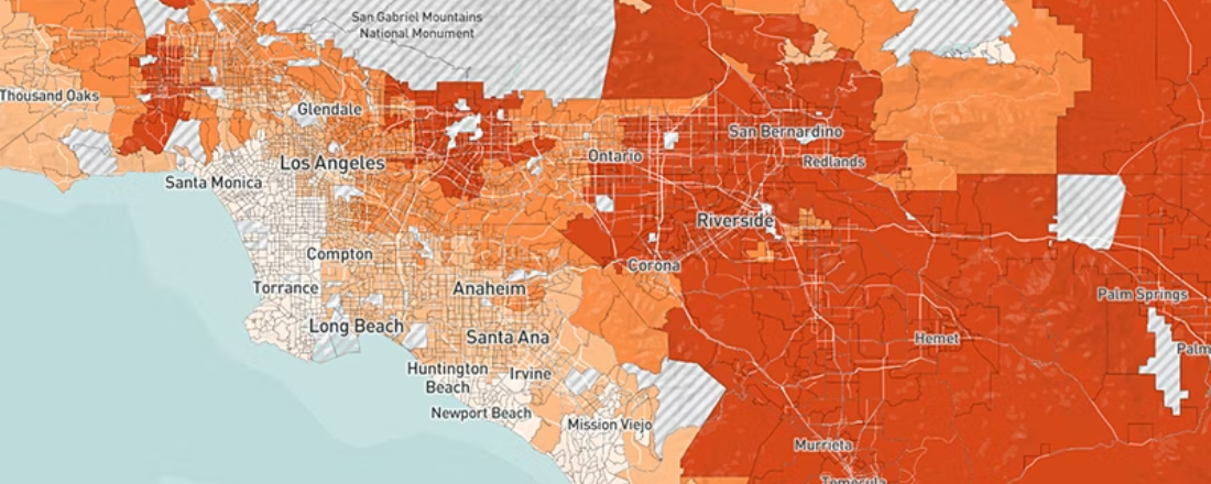
In response to the pressing need for statewide data platforms that predict how our communities can withstand rising temperatures, the Public Health Alliance of Southern California (the Alliance) based at the Public Health Institute, in collaboration with the University of California, Los Angeles (UCLA) Luskin Center for Innovation, have co-developed the California Healthy Places Index Extreme Heat Edition (HPI: Extreme Heat Edition). The HPI: Extreme Heat Edition allows journalists, community groups, government entities, schools, tribal organizations, community members, and other key audiences to scan their community and understand which areas and populations are likely to be most affected by heat now and in the years to come.
“Open and accessible data on extreme heat impacts, linked with opportunities and funding sources, is key to empowering communities to build healthy, resilient neighborhoods. The California HPI: Extreme Heat Edition makes these data actionable through an interactive, easy-to-use tool,” said Tracy Delaney, PhD, the founding executive director of the Public Health Alliance of Southern California.
Developed by the Alliance, the Healthy Places Index (HPI) is a peer-reviewed and published tool that measures the impact of community conditions – like safe and affordable housing and access to green spaces – on population health. The HPI is a trusted mapping, data, and policy platform that has been used to direct over $2.3 billion in investments to under-resourced communities across California.
Funded by the California Strategic Growth Council, the HPI: Extreme Heat Edition leverages HPI’s data on community conditions combined with the latest climate projections of extreme heat. Developed based on community input to reflect the needs and priorities of Californians most impacted by climate change, HPI: Extreme Heat Edition is the only neighborhood-level mapping tool in the U.S. that directly embeds resources and recommendations for action alongside its data, all using a positive, asset-based frame. This approach emphasizes the strengths, resources, and opportunities available in a community rather than focusing on the problems faced.
“The Healthy Places Index Extreme Heat Edition is more than data on projected extreme heat in California – it’s designed to help you take that data into action. It gives you the tools to find the places most sensitive to the impacts of extreme heat and to discover resources and opportunities to build resilience together with our communities,” said Helen Dowling, MPH, director of data initiatives at the Alliance.
Using HPI: Extreme Heat Edition, you can explore how California communities with fewer healthy conditions – measured by lower HPI scores – might access resources and programs to better prepare for, respond to, and recover from extreme heat events. The tool helps to understand neighborhoods’ extreme heat risks, evaluate the impact of extreme heat on sensitive populations, and identify resources to foster resilience, including urban greening, low-carbon transit, low-income weatherization programs, and more.
“The Healthy Places Index Extreme Heat Edition can help answer crucial questions, such as, ‘How can we enhance our community’s resilience?’, ‘Where should we invest in expanding cooling center coverage’ or ‘Where should we fund an urban greening project,’” Dowling explained.
Schools and school districts, government agencies, community-serving organizations, tribal organizations and community members can utilize the tool to capture their neighborhoods’ risk for extreme heat, determine who is most impacted and identify resources to help mitigate the effects of heat.
The tool allows users to search by census tract (neighborhood) and rates a neighborhood by how many days it’s predicted to have extreme heat (above 90 degrees) and includes health indicators such as emergency room visits for asthma, heart attack or stroke and diabetes prevalence for different neighborhoods. In addition, the mapping tool captures demographic data, highlighting sensitive population groups that are more likely to experience disproportionate impacts of extreme heat such as communities of color, older adults and persons with disabilities, mothers and infants, non-English speakers and youth.
The tool also provides a search function for valuable resources that exist at the local and statewide level to prepare for rising temperatures.
Journalists: From climate to education and social justice to daily news, journalists covering the complex realities of rising temperatures can use the HPI: Extreme Heat Edition to streamline the storytelling process. Curious about which zip codes or school districts within a specific city can be most impacted? It’s there. Need to identify subpopulations disproportionately affected within neighborhoods to interview? It’s covered. The HPI: Extreme Heat Edition is more than a guide—it’s a tool that empowers reporters to visualize and compare how even unincorporated communities are bracing for unprecedented heat waves. With access to crucial data and visualizations, journalists can use this extreme heat tool to help pitch compelling stories, uplift the voices of those most impacted, craft hard-hitting questions for officials, and tell stories that make a difference.
Schools and school districts: Extreme heat has led to school closures in under-resourced areas. Using the HPI: Extreme Heat Edition, school administrators can select the “School Districts” geography and see what districts will likely be most impacted by heat. Administrators can then head to “Resources to Address Extreme Heat” to find funding programs to weatherize classrooms and playgrounds.
Community serving organizations: Organizations in communities facing historic and ongoing divestment can utilize HPI: Extreme Heat Edition to identify many funding programs – ranging from grant initiatives that support tribal organizations in areas affected by pollution – to programs for urban greening projects and more.
Community members: The extreme heat index tool allows community members to identify programs like low-income weatherization to help make their home more energy efficient and help pay for high energy costs (i.e. air conditioner replacement or repair for families working to make ends meet).
Note for media: Press can utilize soundbytes/b-roll with proper attribution to the “Public Health Alliance of Southern California based at the Public Health Institute.” You can access these resources here. An interview log and VOSOT script are available upon request by emailing Allison Walker at: awalker@phi.org.

You change the world. We do the rest. Explore fiscal sponsorship at PHI.
Together, we can accelerate our response to public health’s most critical issues.
Begin your career at the Public Health Institute.

Communities across the U.S. and around the world are grappling with dangerous wildfires and extreme heat. Explore PHI's resources, tools, programs and impacts to help protect your community—with a focus on ways to reach systemically excluded groups with key resources and information, and invest in transformative solutions to promote safety, equity and resiliency.